MOBILISE 3.0 is a digital platform which provides the local stakeholders with a set of digital solutions for supporting climate adaptation and resilience activities.
It enables multi-agency collaboration and community engagement and facilitates participatory approach for implementing climate adaptation and resilient measures against climate change. Using its data management capabilities, stakeholders can use the MOBILISE 3.0 platform to establish a rich picture of the local hazards, exposure and vulnerabilities by bringing data from a range of sources such as sensors, satellites, city information systems and climate impact simulations.
Using the easy to use visual interfaces of MOBILISE 3.0, stakeholders and communities can work together to explore the impact of climate induced hazards on their local environment, and discuss and agree interventions for building community resilience.
It is evident that due to climate change hazards such as floods, landslides, heatwaves, wild-fire and storm surge will continue to exacerbate, causing direct impact on economy, food and water security, as well as citizen’s health. The risk level posed by climate change on urban environments will depend on how climate adaptation and resilient measures are implemented by local stakeholder to safeguard physical, social and environmental infrastructures. Therefore it is important for local government agencies to consider climate adaptation and resilience measures and make complex trade-offs in their decision-making processes in land-use management and urban development. However, the knowledge and level of collaboration required for such complex decisions span across many scientific and engineering disciplines, and government agencies, hence requiring an interdisciplinary approach.
MOBILISE 3.0 enables you to integrate data and knowledge from various disciplines and teams to establish an accurate picture of the climate risks across time and space, and work together with communities to develop sound interventions for building climate adaptation and resilient measures.
MOBILISE 3.0 can help you do the following:
☑ Establish a local or national shared risk information space for your stakeholders to gain an accurate understanding of the localised climate risks.
☑ Run various climate risks scenarios to understand their impact on your urban infrastructure and the communities.
☑ Integrate various disjointed sensor networks to collect intelligence on emerging hazards such as floods and landslides.
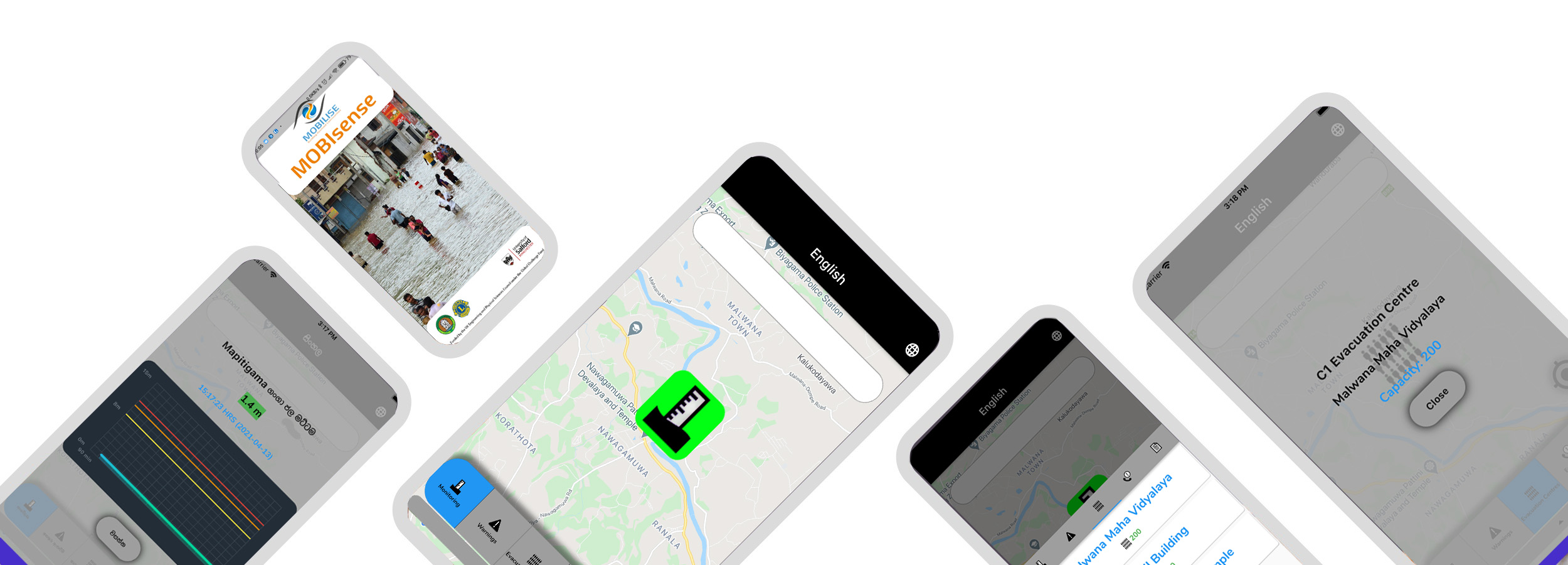
☑ Establish an Early Warning System that digitally connects the relevant agencies, NGOs and communities to disseminate early warnings efficiently.
☑ Mobile app for citizens for receiving early warning messages and providing intelligence from the ground.
☑ Drone based digital environment that can be used for implementing disaster mitigation plans and post-disaster reconstruction.
At the heart of MOBILISE 3.0 is a cloud-based risk information space, referred to as the MOBILISE: Data Engine.
It allows local councils or local disaster management committees to capture and maintain their local intelligence on exposure, vulnerability and potential hazards. In addition, the MOBILISE: Data Engine offers important data management
functionalities such as data cleansing, styling of data layers to enhance visual appearance, attaching of metadata such as origin of the data layers, year of data collection, star rating based on its quality, security level etc. This
risk information can then be used by the other MOBILISE digital services to offer a range of collaborative disaster resilience activities by the government agencies, NGOs and the local community.
MOBILISE: Risk Explorer: This tool allows local stakeholders to come together to explore the local risk information spaces in an interactive manner to establish a common understanding of the local risks that exist in their area.
The MOBILISE: Risk Explorer offers two modes of operations: configuration mode and risk exploration mode. The configuration mode can be used by the stakeholders to select the necessary information from the MOBILISE: Data Engine and categorise it according to their way of representing exposure, hazards and vulnerability information. For example, the users can categorise the exposure data under sub-categories such as critical infrastructure, residential buildings, natural infrastructure etc. This categorisation is then automatically used by the MOBILISE: Risk Explorer to produce an easy-to-use map-based visual interface with interactive icons to support risk exploration. During the risk exploration phase, these virtual icons can be used to select and visualise various hazards and exposure data layers to understand the local risks.
MOBILISE: Scenario Generator: This tool allows government agencies to consider possible future hazards due to climate change and to gain an in-depth understanding of the magnitude of the affected population, impacted roads and critical infrastructure, potential damages and losses within different administrative boundaries. This information can be used by the stakeholders to prepare for disaster response as well as to initiate various mitigation and adaptation plans to reduce the impact of such future disasters on the community and their local infrastructure.
The MOBILISE: Scenario Generator offers two modes of operation: a scenario configuration mode and a scenario exploration model. The scenario configuration mode can be used by the stakeholders to select the hazard information layer and exposure layers for a given hazard from the MOBILISE: Data Engine and process this information to calculate the impact of that hazard on the local community using the in-built MOBILISE GIS services. Once the calculation is completed, the stakeholders can invoke the scenario exploration mode to explore the impact of that disaster within different local boundaries, using an interactive visual map and an infographic interface.
The MOBILISE: IoT Network Integrator: Our research has shown that many countries have many isolated sensor networks for monitoring rainfall, river level and flow rates in order to issue early warnings to the communities. These sensor networks are owned by various government agencies and NGOs and their use is typically restricted within each organisation. This restricted use results in poor situational intelligence for issuing accurate early warning messages to the community, due to insufficient real-time sensor data.
The MOBILISE: IoT Network Integrator offers the functionality for integrating these disconnected sensor networks to establish better situational intelligence for issuing more accurate early warning messages to the community at risk. Furthermore, it offers the opportunity to make the real-time sensor information available to the local councils, disaster management committees and communities so that they can, themselves, establish community-based hazard monitoring systems to prepare better for early evacuation.
The MOBILISE: Early Warning System: This tool allows national or local agencies to digitize their early warning dissemination methods so that warnings can be sent more efficiently and effectively to the community at risk, hence potentially saving lives. In every country, typically one government organisation is mandated for monitoring the emerging hazards on the ground and issuing appropriate disaster alerts. These alerts are then passed through to a few other government organisations which have the overall responsibility for coordinating early warnings at the national and at the local levels. These organisations are also responsible for disseminating these alerts to the media, NGOs and community representatives to achieve a broader coverage. However, at present, in many countries these early warnings are forwarded through traditional methods, such as faxes and telephone communications, introducing delays in reaching the communities.
The MOBILISE: Early Warning System provides a digital workflow system to disseminate the early warnings more efficiently to the relevant national and local agencies as well as to the NGOs and to the community leaders. Furthermore, the MOBILISE workflow system can be used to send the early warnings directly to the citizens living in the risk area through the MOBILISE MOBISense app. All the early warnings, made during a disaster, are maintained in the workflow engine in order to allow the stakeholders to analyse any delays caused in reaching the community and bring continuous improvement to their early warning message passing process.
The MOBILISE: Drone Inspector: This tool provides the construction of 3D environments from live drone data so that responders can establish situational awareness during a disaster. It allows the responders to identify the magnitude of the disaster impact through aerial inspection and to plan their rescue operations.
The MOBILISE: Construction Planner: This tool allows the engineers to visualise drone scanned data of landslide sites and to work with other stakeholders to discuss and agree landslide mitigation solutions. It offers a range of functionalities such as point measurements, slope measurements, volume calculations, land editing and monitoring of the land reconstruction activities during the land reconstruction process.

Eng. (Dr.) Asiri Karunawardena
National Building Research Organisation, Sri Lanka.

We provide bespoke solutions to better support your needs.